

Statistically downscaled climate scenarios
PCIC offers statistically downscaled, daily, Canada-wide climate scenarios, at a gridded resolution of approximately 10km (300 arc-seconds or 1/12°) for the simulated period of 1950-2100. Users can choose between different data sets, models and scenarios, with further information about the options provided in the section below. Within each portal, users can:
- Access modelled historical data and future projections for minimum temperature, maximum temperature and precipitation
- Select specific datasets and filter results by date range
- Zoom, pan and select a region of interest using the interactive map
- Download data in NetCDF or ASCII formats
Climate models and scenarios
A. Coupled Model Intercomparison Project Phase 5 (CMIP5)
Downscaled scenarios were constructed from 27 Global Climate Models (GCMs) and 3 Representative Concentration Pathways (RCPs) from CMIP5, using the BCCAQv2 downscaling method described below. The RCPs represent low (RCP2.6), intermediate (RCP4.5) and high (RCP8.5) rates of greenhouse gas emissions added to the atmosphere between 2006 and 2100. Projections can be selected for any combination of model, RCP, and time period.
This data set is referred to as Canadian Downscaled Climate Scenarios – Univariate (CMIP5), or CanDCS-U5 for short.
B. Coupled Model Intercomparison Project Phase 6 (CMIP6)
Downscaled scenarios were constructed from 26 GCMs and 3 Shared Socioeconomic Pathways (SSPs) from CMIP6, using the two distinct statistical downscaling methods described below. The SSPs represent low (SSP1-2.6), intermediate (SSP2-4.5) and high (SSP5-8.5) rates of greenhouse gas emissions added to the atmosphere between 2013 and 2100. Projections can be selected for any combination of model, SSP, and time period.
The first data set is referred to as Canadian Downscaled Climate Scenarios – Univariate (CMIP6), or CanDCS-U6 for short.
The second data set is referred to as Canadian Downscaled Climate Scenarios – Multivariate (CMIP6), or CanDCS-M6 for short.
C. CanESM5-10 Member Ensemble
Downscaled scenarios were also constructed from 10 distinct realizations of the Canadian Earth System Model Version 5 (CanESM5) running all three SSPs. CanESM5, a CMIP6 model included in CanDCS-M6, was downscaled using the same two downscaling methods described below. This dataset may be useful for those interested in studying the effect of internal climate variability on projected climate change.
If you are uncertain as to which dataset is most appropriate to your intended application, then please consult the next section. Some guidance and information on future emissions scenarios is provided under Further reading at the bottom of this page.
Statistical downscaling methods
Data from each climate model are downscaled to a finer resolution using one or more statistical methods and a gridded, reference observation-based dataset, which constitutes a reconstruction of the actual historical climate over Canada.
Note that for the historical period used to calibrate the downscaling methods (1951-2005 for CMIP5, 1951-2012 for CMIP6) , statistical properties of the downscaled results will, by design, tend to match those of the gridded observational dataset. The day-by-day, month-by-month, year-by-year, etc. sequencing of values, however, will not correspond to observations, since climate models solve a “boundary value problem” and are not constrained to reproduce the timing of natural climate variability (e.g., El Niño-Southern Oscillation) in the observational record.
BCCAQv2 is a hybrid method developed at PCIC that combines results from Bias Corrected Constructed Analogs (BCCA) and Quantile Delta Mapping (QDM). QDM preserves relative changes in GCM quantiles to avoid inflationary effects that can occur with standard quantile mapping. BCCA uses spatial aggregation from a linear combination of historical analogues for daily large-scale fields. BCCAQv2 is an updated version of BCCAQ (version 1), which employed standard quantile mapping.
The MBCn technique adapts the statistical characteristics of a multivariate reference distribution (i.e., gridded observations) to the multivariate distribution of climate model variables.
The method begins with the univariate adjustment of each climate variable, using QDM. Next, the dependence structure between variables is adjusted using a multi-step, iterative process based on an adaptation of an image processing algorithm used to transfer color information. Through an iterative process, this algorithm nudges the multivariate distributions of the historical climate simulations toward the reference observations; by design, the adjusted univariate distributions match those of QDM. Furthermore, the MBCn-downscaled future climate simulations reflect changes in the dependence structure amongst variables.
Reference observational datasets
The gridded observational dataset used to calibrate BCCAQv2, referred to as NRCANmet, was produced by Natural Resources Canada (NRCan) and is available at approximately 10km spatial resolution (300 arc seconds or 1/12°) over Canada.
Daily minimum and maximum temperature, and precipitation amounts for the period 1950-2012 were produced by Hopkinson et al. (2011) and McKenney et al. (2011) on behalf of the Canadian Forest Service (CFS), NRCan.
Gridding was accomplished by implementing the Australian National University Spline (ANUSPLIN) trivariate thin plate splines interpolation method, with latitude, longitude and elevation as predictors. This dataset is also available via the Daily gridded meteorological datasets page. Note that gridded values may differ from climate stations and biases may be present at high elevations or in areas with low station density.The daily, gridded observational dataset used to calibrate MBCn, referred to as PCIC-Blend, is based on three existing data sets:
- NRCANmet-Adjusted Precipitation, which spans Canada.
- NRCANmetV2 Temperature, spanning North America.
- PNWNAmet, covering Western Canada and the Pacific Northwest.
The first two datasets are recently upgraded versions of the NRCANmet dataset used to create CanDCS-U5 and CanDCS-U6. The third dataset is available on the PCIC Data Portal under Daily gridded meteorological datasets.
While the updated NRCANmet datasets display notable improvements over the earlier version across central and eastern Canada, their performance is inferior to PNWNAmet over western Canada when compared to high quality station observations. Hence, PNWNAmet values were blended with the NRCANmet values over a small overlap region stretching from southwest Alberta to northeast Yukon, using NRCANmetV2 for temperature and NRCANmet-Adjusted for precipitation. See the Daily gridded meteorological datasets page for further details on the construction of PCIC-Blend.Model subsets
Analysis and storage of the full climate model ensemble is often not feasible. For the CanDCS-U5 ensemble, a 12-model subset was selected based on the KKZ method, which was designed to capture 90% of the range of projected changes in temperature and precipitation in all seasons for the Climdex suite of extreme indices under RCP4.5.
Recommended subsets of models are provided for a number of geographic sub-regions of North America, known as Giorgi regions (see Figure 1). Note, however, that data are only available for the parts of the Giorgi regions that lie within Canada. If fewer than 12 GCM runs are desired, they should be chosen following the order listed for each sub-region in Table 2. Note that only 9 of the 12 GCM runs are available for RCP2.6.
Figure 1: Giorgi regions that intersect with Canada: Alaska (ALA), Western North America (WNA), Central North America (CNA), Greenland (GRL), Eastern North America (ENA) and Central America (CAM).
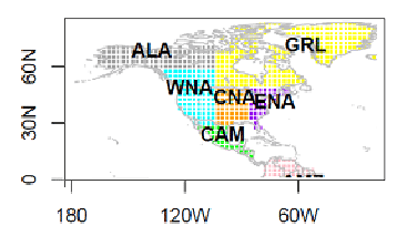
Table 1: Model ensembles and Giorgi regions.
| Model Ensembles and Giorgi Regions | |||||
|
Order |
WNA |
ALA |
CNA |
ENA |
GRL |
|
1 |
CNRM-CM5-r1 |
CSIRO-Mk3-6-0-r1 |
CanESM2-r1 |
MPI-ESM-LR-r3 |
MPI-ESM-LR-r3 |
|
2 |
CanESM2-r1 |
HadGEM2-ES-r1 |
ACCESS1-0-r1 |
inmcm4-r1 |
inmcm4-r1 |
|
3 |
ACCESS1-0-r1 |
inmcm4-r1 |
inmcm4-r1 |
CNRM-CM5-r1 |
CanESM2-r1 |
|
4 |
inmcm4-r1 |
CanESM2-r1 |
CSIRO-Mk3-6-0-r1 |
CSIRO-Mk3-6-0-r1 |
CNRM-CM5-r1 |
|
5 |
CSIRO-Mk3-6-0-r1 |
ACCESS1-0-r1 |
MIROC5-r3 |
HadGEM2-ES-r1 |
ACCESS1-0-r1 |
|
6 |
CCSM4-r2 |
MIROC5-r3 |
HadGEM2-ES-r1 |
CanESM2-r1 |
CSIRO-Mk3-6-0-r1 |
|
7 |
MIROC5-r3 |
HadGEM2-CC-r1 |
MPI-ESM-LR-r3 |
MRI-CGCM3-r1 |
HadGEM2-ES-r1 |
|
8 |
MPI-ESM-LR-r3 |
MRI-CGCM3-r1 |
CNRM-CM5-r1 |
CCSM4-r2 |
MIROC5-r3 |
|
9 |
HadGEM2-CC-r1 |
CCSM4-r2 |
CCSM4-r2 |
MIROC5-r3 |
HadGEM2-CC-r1 |
|
10 |
MRI-CGCM3-r1 |
CNRM-CM5-r1 |
GFDL-ESM2G-r1 |
ACCESS1-0-r1 |
CCSM4-r2 |
|
11 |
GFDL-ESM2G-r1 |
MPI-ESM-LR-r3 |
HadGEM2-CC-r1 |
HadGEM2-CC-r1 |
MRI-CGCM3-r1 |
|
12 |
HadGEM2-ES-r1 |
GFDL-ESM2G-r1 |
MRI-CGCM3-r1 |
GFDL-ESM2G-r1 |
GFDL-ESM2G-r1 |
For CMIP6, the model subsetting method applied for CMIP5 was improved in three main respects. First, the full set of 26 GCMs was screened to account for models that have a significant “shared history” of development, which produces redundancy in model outputs. Second, the issue of scenario dependence was addressed by use of a cross-scenario selection strategy, specifically by applying the KKZ method to future climate index changes for all SSPs at a specified level of global warming, namely 2 ℃. Third, subsets were produced for both Canada and 5 sub-regions located entirely within Canada. Additional improvements included using the downscaled (instead of raw) GCM results to compute indices and the removal of redundant indices from the procedure.
For CMIP6, recommended subsets of models are provided in the Tables below for Canada, along with a number of its sub-regions shown in the accompanying map. The national subset comprises 12 GCMs and is identical for both CanDCS-U6 and CanDCS-M6.
Users interested in climate projections for a single region are advised to use the corresponding regional subset listed in the Tables, while those studying more than one region should use the Canada-wide subsets. The number of GCMs in the regional subsets ranges from 8 to 11, depending on the downscaling method and region. As for the national subsets, there is a high degree of overlap between the downscaled GCMs from the two methods.
Further details about this selection method can be found in the project report, Downscaled CMIP6 Climate Model Subset Selection.
Figure 2: Regions of Canada used for downscaled CMIP6 GCM subset selection.
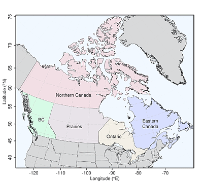
Table 2: Cross-scenario, KKZ-selected GCM subsets for Canada and each of its subregions, from the CanDCS-U6 downscaled CMIP6 scenarios. Models in grey shaded cells differ from those in the CanDCS-M6 subsets shown in the next table.
|
Canada |
Eastern Canada |
Ontario |
Prairies |
British Columbia |
Northern Canada |
|
|
1 |
BCC-CSM2-MR |
GFDL-ESM4 |
BCC-CSM2-MR |
BCC-CSM2-MR |
TaiESM1 |
CanESM5 |
|
2 |
NorESM2-LM |
NorESM2-LM |
NorESM2-LM |
EC-Earth3-Veg |
NorESM2-LM |
INM-CM5-0 |
|
3 |
MIROC-ES2L |
MIROC-ES2L |
MIROC-ES2L |
UKESM1-0-LL |
CNRM-ESM2-1 |
NorESM2-LM |
|
4 |
MPI-ESM1-2-HR |
FGOALS-g3 |
UKESM1-0-LL |
NorESM2-LM |
IPSL-CM6A-LR |
MRI-ESM2-0 |
|
5 |
MRI-ESM2-0 |
MRI-ESM2-0 |
EC-Earth3-Veg |
FGOALS-g3 |
MIROC-ES2L |
MPI-ESM1-2-HR |
|
6 |
UKESM1-0-LL |
EC-Earth3-Veg |
ACCESS-ESM1-5 |
INM-CM5-0 |
MRI-ESM2-0 |
ACCESS-ESM1-5 |
|
7 |
EC-Earth3-Veg |
INM-CM5-0 |
INM-CM5-0 |
MRI-ESM2-0 |
UKESM1-0-LL |
CMCC-ESM2 |
|
8 |
CMCC-ESM2 |
CanESM5 |
GFDL-ESM4 |
MPI-ESM1-2-HR |
EC-Earth3-Veg |
UKESM1-0-LL |
|
9 |
INM-CM5-0 |
|
CNRM-ESM2-1 |
CNRM-ESM2-1 |
MPI-ESM1-2-HR |
|
|
10 |
FGOALS-g3 |
|
CanESM5 |
IPSL-CM6A-LR |
FGOALS-g3 |
|
|
11 |
TaiESM1 |
|
MRI-ESM2-0 |
|
|
|
|
12 |
IPSL-CM6A-LR |
|
|
|
|
Table 3: Cross-scenario, KKZ-selected GCM subsets for Canada and each of its subregions, from the CanDCS-M6 downscaled CMIP6 scenarios. Models in grey shaded cells differ from those in the CanDCS-U6 table shown above.
|
Canada |
Eastern Canada |
Ontario |
Prairies |
British Columbia |
Northern Canada |
|
|
1 |
BCC-CSM2-MR |
GFDL-ESM4 |
BCC-CSM2-MR |
BCC-CSM2-MR |
TaiESM1 |
CanESM5 |
|
2 |
NorESM2-LM |
NorESM2-LM |
UKESM1-0-LL |
EC-Earth3-Veg |
NorESM2-LM |
INM-CM5-0 |
|
3 |
UKESM1-0-LL |
MIROC-ES2L |
NorESM2-LM |
UKESM1-0-LL |
CNRM-ESM2-1 |
NorESM2-LM |
|
4 |
MRI-ESM2-0 |
FGOALS-g3 |
MIROC-ES2L |
NorESM2-LM |
MPI-ESM1-2-HR |
MPI-ESM1-2-HR |
|
5 |
MPI-ESM1-2-HR |
MRI-ESM2-0 |
ACCESS-ESM1-5 |
FGOALS-g3 |
FGOALS-g3 |
MRI-ESM2-0 |
|
6 |
EC-Earth3-Veg |
UKESM1-0-LL |
EC-Earth3-Veg |
INM-CM5-0 |
UKESM1-0-LL |
ACCESS-ESM1-5 |
|
7 |
MIROC-ES2L |
EC-Earth3-Veg |
INM-CM5-0 |
MRI-ESM2-0 |
MIROC-ES2L |
TaiESM1 |
|
8 |
INM-CM5-0 |
INM-CM5-0 |
CanESM5 |
TaiESM1 |
MRI-ESM2-0 |
CMCC-ESM2 |
|
9 |
CMCC-ESM2 |
BCC-CSM2-MR |
CNRM-ESM2-1 |
CNRM-ESM2-1 |
IPSL-CM6A-LR |
BCC-CSM2-MR |
|
10 |
FGOALS-g3 |
IPSL-CM6A-LR |
MRI-ESM2-0 |
ACCESS-ESM1-5 |
|
EC-Earth3-Veg |
|
11 |
TaiESM1 |
|
GFDL-ESM4 |
|
|
|
|
12 |
IPSL-CM6A-LR |
|
|
|
|
Additional information
| Dataset Versions | |||||
|
Dataset |
Version |
Date |
Variables |
Other Notes |
|
|
CanDCS-M6 |
1.1 |
November 2023 |
PR |
Revisions applied to a small number of instances of anomalously high precipitation values in certain situations. |
|
|
CanDCS-U6 |
1.1 |
October 2023 |
TX, TN |
Rerun of HadGEM3-GC31-LL, KACE-1-0-G, UKESM1-0-LL TX scenarios after correcting sporadic, anomalously high TX values in the GCMs. Rerun of KACE-1-0-G TN scenarios after correcting an error in a KACE-1-0-G GCM grid cell in northern Canada. |
|
|
CanDCS-M6 |
1 |
July 2023 |
PR, TX, TN |
First online distribution. |
|
|
CanDCS-U6 |
1 |
December 2021 |
PR, TX, TN |
First online distribution. |
|
|
CanDCS-U5 |
1 |
November 2016 |
PR, TX, TN |
First online distribution. |
|
When referring to the Statistically downscaled climate scenarios produced by PCIC, whether retrieved from this website or found otherwise, the source must be clearly stated. For the most recently released data, the following citation is recommended:
Citation for CanDCS-U5:
"Pacific Climate Impacts Consortium, University of Victoria, (Feb. 2019). Statistically Downscaled Climate Scenarios. Downloaded from https://data.pacificclimate.org/portal/downscaled_gcms/map/ on <date>. Method: BCCAQ v2.” (Please also specify GCMs, RCPs, domain of download, and downloaded variables. Citation of relevant references, as provided below, is also recommended where appropriate.)
Citation for CanDCS-U6:
"Pacific Climate Impacts Consortium, University of Victoria, (Dec. 2021). Statistically Downscaled Climate Scenarios. Downloaded from https://data.pacificclimate.org/portal/downscaled_cmip6/map/ on <date>. Method: BCCAQv2.” (Please also specify GCMs, SSPs, domain of download, and downloaded variables. Citation of relevant references, as provided below, is also recommended where appropriate.)
"Pacific Climate Impacts Consortium, University of Victoria, (July 2023). Statistically Downscaled Climate Scenarios. Downloaded from https://data.pacificclimate.org/portal/downscaled_cmip6/map/ on <date>. Method: MBCn.” (Please also specify GCMs, SSPs, domain of download, and downloaded variables. Citation of relevant references, as provided below, is also recommended where appropriate.)
PCIC gratefully acknowledges support from Environment and Climate Change Canada for supporting the development of the statistically downscaled GCM scenarios that are distributed from this data portal.
We acknowledge the World Climate Research Programme’s Working Group on Coupled Modelling, which is responsible for CMIP5 and CMIP6, and we thank the climate modeling groups for producing and making available their GCM output.
For CMIP the U.S. Department of Energy’s Program for Climate Model Diagnosis and Intercomparison provides coordinating support and led development of software infrastructure in partnership with the Global Organization for Earth System Science Portals.
Finally, we thank the Landscape Analysis and Applications section of the Canadian Forest Service, Natural Resources Canada for developing and making available the Canada-wide historical daily gridded climate datasets used as the downscaling targets.
To learn more about CMIP5, CMIP6, CanESM5 and future emissions scenarios, see:
Taylor, K.E., R.J. Stouffer, and G.A. Meehl, 2012: An Overview of CMIP5 and the Experiment Design. Bulletin of the American Meteorological Society, 93, 485–498. doi: 10.1175/BAMS-D-11-00094.1.
van Vuuren, D.P., et al., 2011: The Representative Concentration Pathways: An Overview. Climatic Change, 109 (1-2), 5-31, doi:10.1007/s10584-011-0148-z.
Eyring, V., S. Bony, G.A. Meehl, C. Senior, B. Stevens, R.J. Stouffer and K.E. Taylor, 2016: Overview of the Coupled Model Intercomparison Project Phase 6 (CMIP6) experimental design and organization. Geoscientific Model Development, 9(5), 1937-1958. doi: 10.5194/gmd-9-1937-2016.
Riahi, K. et al. 2017: The Shared Socioeconomic Pathways and their energy, land use, and greenhouse gas emissions implications: An overview. Global Environmental Change, 42, 153-168, doi:10.1016/j.gloenvcha.2016.05.009.
Pacific Climate Impacts Consortium. 2023: PCIC Primer: Understanding Future Climate Scenarios.
Swart, N.C., J.N.S. Cole, V.V. Kharin, M. Lazare, J.F. Scinocca, N.P. Gillett, J. Anstey, V. Arora, J.R. Christian, S. Hanna, Y. Jiao, W.G. Lee, F. Majaess, O. Saenko, C. Seiler, C. Seinen, A. Shao, M. Sigmond, L. Solheim, K. von Salzen, D. Yang and B. Winter, 2019: The Canadian Earth System Model version 5 (CanESM5.0.3). Geoscientific Model Development, 12(11), 4823–4873, doi:10.5194/gmd-12-4823-2019.
For more information on the reference observational datasets used for CanDCS-U5 and CanDCS-U6, see:
Hopkinson, R.F., D.W. McKenney, E.J. Milewska, M.F. Hutchinson, P. Papadopol, and L.A. Vincent, 2011: Impact of Aligning Climatological Day on Gridding Daily Maximum–Minimum Temperature and Precipitation over Canada. Journal of Applied Meteorology and Climatology, 50, 1654–1665. doi:10.1175/2011JAMC2684.1.
McKenney, D.W., M.F. Hutchinson, P. Papadopol, K. Lawrence, J. Pedlar, K. Campbell, E. Milewska, R. Hopkinson, D. Price, and T. Owen, 2011: Customized spatial climate models for North America. Bulletin of the American Meteorological Society, 92, 12, 1611-1622. doi:10.1175/2011BAMS3132.1.
For CanDCS-M6, see:
MacDonald, H. et al., 2020: North American historical monthly spatial climate dataset, 1901–2016. Scientific Data, 7, 411. doi:10.1038/s41597-020-00737-2.
MacDonald, H., D.W. McKenney, X.L. Wang, J. Pedlar, P. Papadopol, K. Lawrence, Y. Feng and M.F. Hutchinson, 2021: Spatial Models of Adjusted Precipitation for Canada at Varying Time Scales. Journal of Applied Meteorology and Climatology, 60, 3, 291–304, doi:10.1175/JAMC-D-20-0041.1.
Sobie, S.R., Ouali, D., Curry, C.L., Zwiers, F.W., 2024. Multivariate Canadian Downscaled Climate Scenarios for CMIP6 (CanDCS-M6). Geoscience Data Journal. 11, 806-824, doi:10.1002/gdj3.257.
To learn more about the statistical downscaling methods PCIC employs, see:
Hunter, R. D. and R. K. Meentemeyer, 2005: Climatologically Aided Mapping of Daily Precipitation and Temperature. Journal of Applied Meteorology, 44, 1501–1510, doi:10.1175/JAM2295.1.
Cannon, A.J., S.R. Sobie, and T.Q. Murdock, 2015: Bias Correction of GCM Precipitation by Quantile Mapping: How Well Do Methods Preserve Changes in Quantiles and Extremes? Journal of Climate, 28(17), 6938-6959, doi:10.1175/JCLI-D-14-00754.1.
Cannon, A. J., 2018: Multivariate quantile mapping bias correction: an N-dimensional probability density function transform for climate model simulations of multiple variables. Climate Dynamics, 50, 31-49, doi:10.1007/s00382-017-3580-6.
Werner, A. T. and Cannon, A. J., 2016: Hydrologic extremes – an intercomparison of multiple gridded statistical downscaling methods, Hydrology and Earth System Sciences, 20, 1483-1508, doi:10.5194/hess-20-1483-2016.
Hiebert, J., A. Cannon, A. Schoeneberg, S. Sobie, and T. Murdock, 2018: ClimDown: Climate Downscaling in R. The Journal of Open Source Software, 3(22), 360, doi:10.21105/joss.00360.
The model subsetting procedure used for CanDCS is described in:
Cannon, A.J., 2015: Selecting GCM scenarios that span the range of changes in a multimodel ensemble: application to CMIP5 climate extremes indices. Journal of Climate, 28, 3, 1260-1267. doi:10.1175/JCLI-D-14-00636.1
This data has been obtained from a variety of sources and is provided as a public service by the Pacific Climate Impacts Consortium. The data is provided by the Consortium on an “AS IS” basis without any warranty or representation, express or implied, as to its accuracy or completeness. Any reliance you place upon the information contained here is your sole responsibility and is strictly at your own risk. In no event will the Consortium be liable for any loss or damage whatsoever, including without limitation, indirect or consequential loss or damage, arising from reliance upon the data or derived information.
In addition to PCIC's terms of use, the data are subject to the terms of use of each source organization. For further details please refer to: